
Restren:Stewart Island map-en.svg

Size of this PNG preview of this SVG file: 800 × 585 piksel. Klerderyow erel: 320 × 234 piksel | 640 × 468 piksel | 1,024 × 748 piksel | 1,280 × 936 piksel | 2,560 × 1,871 piksel | 2,237 × 1,635 piksel.
Restren wreydhek (Restren SVG, 2,237 × 1,635 piksel yn hanow, myns an restren: 1.7 MB)
| Restren dhyworth Wikimedia Commons yw hebma. Yma diskwedhys a-woles derivadow dhyworth y folen deskrifans ena. | Mos dhe folen an restren war Wikimedia Commons |
Berrskrif
| Deskrifans |
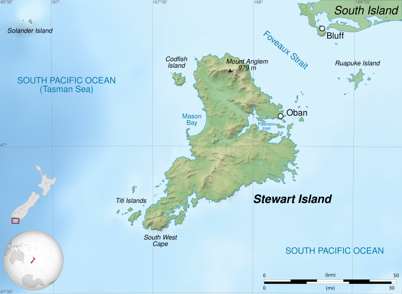
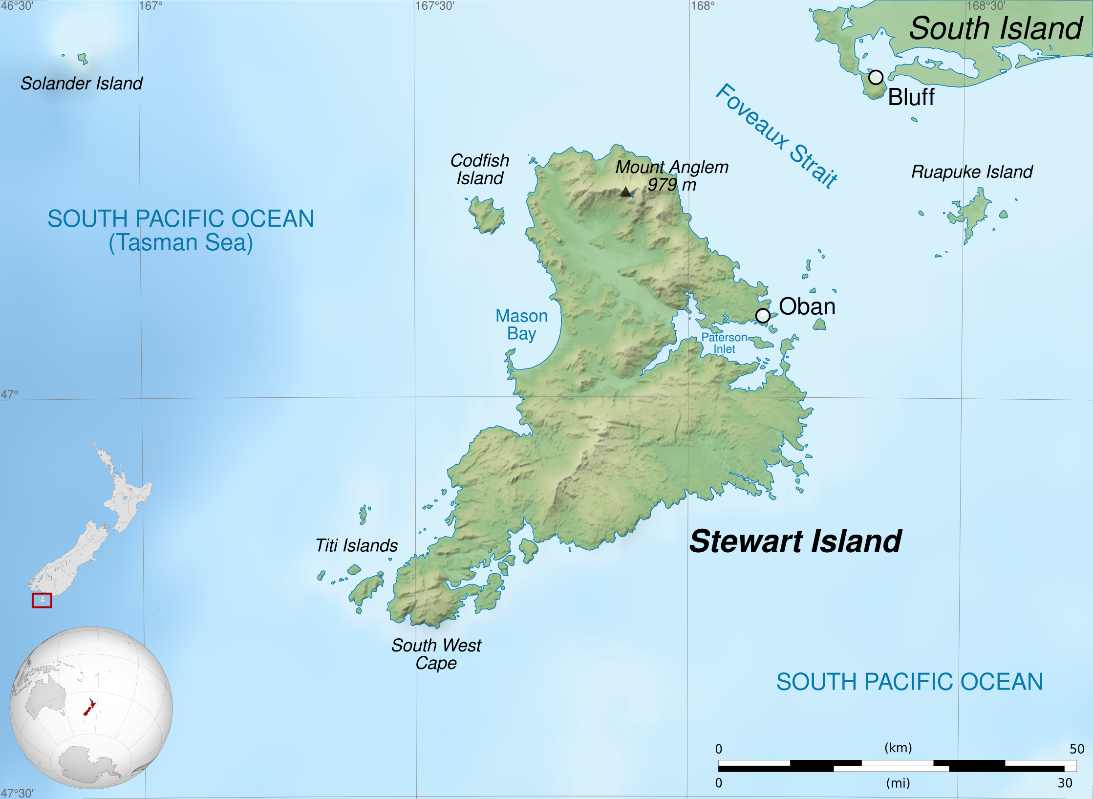
English: Map of Stewart Island / Rakiura, New Zealand.
Geographic limits of the map:
Français : Carte de l'île Stewart, au sud de la Nouvelle-Zélande.
Limites géographiques de la carte :
|
||
| Dedhyans | |||
| Pennfenten |
Ober honan. English:
Français : |
||
| Awtour | Sémhur (talk) | ||
| Other versions |
| ||
| Askrifans (required by the license) | © Sémhur / Wikimedia Commons / | ||
| SVG | W3C-validity not checked.
|
||
| Graphic Lab |


| Camera location | | View this and other nearby images on: OpenStreetMap |
|---|
Leshyans
I, the copyright holder of this work, hereby publish it under the following licenses:
| Copyleft: This work of art is free; you can redistribute it and/or modify it according to terms of the Free Art License. You will find a specimen of this license on the Copyleft Attitude site as well as on other sites. |
This file is licensed under the Creative Commons Attribution-Share Alike 4.0 International, 3.0 Unported, 2.5 Generic, 2.0 Generic and 1.0 Generic license.
- Yma'n gwir dhywgh:
- a ranna – a dhasskrifa, lesranna ha treuskorra an ober
- a gemyska – a aswiwa an ober
- Yn-dann an ragselyow a syw:
- askrifans – Res yw dhywgh ri askrifans gwiw, provia kevren dhe'n lecyans, ha meneges mar peu chanjyow gwrys. Hwi a yll gul hemma yn fordh resonus a vynnowgh, mes ny yllir y wul yn fordh a broffo synser an lecyans dh'agas skoodhya po agas devnydh.
- ranna kehaval – Mar kwrewgh hwi chanjya, treusfurvya po drehevel war an ober ma, res yw dhywgh lesranna agas kevrohow yn-dann an keth lecyans hag an derowel, po lecyans kesplegadow.
You may select the license of your choice.
Istori an restren
Klyckyewgh war dhedhyans/eur rag gweles an folen dell o an termyn na.
| Dedhyans/Eur | Skeusennik | Mynsow | Devnydhyer | Kampol | |
|---|---|---|---|---|---|
| a-lemmyn | 21:39, 3 Hwevrer 2020 | | 2,237 × 1,635 (1.7 MB) | Sémhur | Correct scale |
| 07:58, 2 Metheven 2014 |  | 2,237 × 1,635 (1.7 MB) | Sémhur | Valid SVG | |
| 21:22, 27 Ebrel 2011 |  | 2,237 × 1,635 (1.7 MB) | Sémhur | == {{int:filedesc}} == {{Information |Description={{Multilingual description |en=Map of en:Stewart Island / Rakiura, New Zealand. * Altitude levels: 50 m, 125, 250, 500, etc. (same for bathymetry). * Projection: New Zealand Geodetic Datum 2000 ; GRS |
Devnydh an restren
Yma an folen a syw owth usya an restren ma:
Devnydh ollvysel an restren
Yma an wikis erel a syw ow tevnydhya an restren ma:
- Devnydh war ast.wikipedia.org
- Devnydh war bn.wikipedia.org
- Devnydh war br.wikipedia.org
- Devnydh war de.wikipedia.org
- Devnydh war en.wikipedia.org
- Devnydh war fa.wikipedia.org
- Devnydh war fi.wikipedia.org
- Devnydh war gl.wikipedia.org
- Devnydh war hu.wikipedia.org
- Devnydh war lt.wikipedia.org
- Devnydh war lv.wikipedia.org
- Devnydh war ml.wikipedia.org
- Devnydh war nl.wikipedia.org
- Devnydh war no.wikipedia.org
- Devnydh war pl.wikipedia.org
- Devnydh war simple.wikipedia.org
- Devnydh war sl.wikipedia.org
- Devnydh war sv.wikipedia.org
- Devnydh war ta.wikipedia.org
- Devnydh war th.wikipedia.org
- Devnydh war uk.wikipedia.org
- Devnydh war vi.wikipedia.org
- Devnydh war zh.wikipedia.org