
Restren:Isle of Man map-en.svg

Size of this PNG preview of this SVG file: 654 × 600 piksel. Klerderyow erel: 262 × 240 piksel | 524 × 480 piksel | 838 × 768 piksel | 1,117 × 1,024 piksel | 2,234 × 2,048 piksel | 1,200 × 1,100 piksel.
Restren wreydhek (Restren SVG, 1,200 × 1,100 piksel yn hanow, myns an restren: 686 KB)
| Restren dhyworth Wikimedia Commons yw hebma. Yma diskwedhys a-woles derivadow dhyworth y folen deskrifans ena. | Mos dhe folen an restren war Wikimedia Commons |

Berrskrif
| Deskrifans |
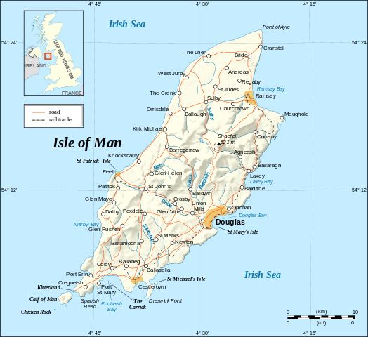
English: Map in English of the Isle of Man.
Note : The shaded relief is a raster image embedded in the SVG. Français : Carte en anglais de l'Île de Man. Note : Le relief ombré est une image bitmap incrustée dans le fichier SVG. UTM projection; WGS84 datum; shaded relief (composite image of N-W, W and N lightning positions); |
||
| Dedhyans | |||
| Pennfenten |
Own work ;
|
||
| Awtour | Eric Gaba (Sting - fr:Sting) | ||
| Kummyas (Dastevnydhya an restren ma) |
|
||
| Other versions |
[]
|


|
This SVG file contains embedded text that can be translated into your language, using any capable SVG editor, text editor or the SVG Translate tool. For more information see: About translating SVG files. |
Leshyans
I, the copyright holder of this work, hereby publish it under the following licenses:

|
Permission is granted to copy, distribute and/or modify this document under the terms of the GNU Free Documentation License, Version 1.2 or any later version published by the Free Software Foundation; with no Invariant Sections, no Front-Cover Texts, and no Back-Cover Texts. A copy of the license is included in the section entitled GNU Free Documentation License. |
| Yma an restren ma yn-dann an leshyans Creative Commons Attribution-Share Alike 3.0 Unported. | ||
| ||
| This licensing tag was added to this file as part of the GFDL licensing update. |
This file is licensed under the Creative Commons Attribution-Share Alike 2.5 Generic, 2.0 Generic and 1.0 Generic license.
- Yma'n gwir dhywgh:
- a ranna – a dhasskrifa, lesranna ha treuskorra an ober
- a gemyska – a aswiwa an ober
- Yn-dann an ragselyow a syw:
- askrifans – Res yw dhywgh ri askrifans gwiw, provia kevren dhe'n lecyans, ha meneges mar peu chanjyow gwrys. Hwi a yll gul hemma yn fordh resonus a vynnowgh, mes ny yllir y wul yn fordh a broffo synser an lecyans dh'agas skoodhya po agas devnydh.
- ranna kehaval – Mar kwrewgh hwi chanjya, treusfurvya po drehevel war an ober ma, res yw dhywgh lesranna agas kevrohow yn-dann an keth lecyans hag an derowel, po lecyans kesplegadow.
You may select the license of your choice.
Istori an restren
Klyckyewgh war dhedhyans/eur rag gweles an folen dell o an termyn na.
| Dedhyans/Eur | Skeusennik | Mynsow | Devnydhyer | Kampol | |
|---|---|---|---|---|---|
| a-lemmyn | 14:38, 4 Gwynngala 2008 | | 1,200 × 1,100 (686 KB) | Sting | New standard colors |
| 23:03, 21 Me 2007 |  | 1,200 × 1,100 (786 KB) | Sting | {{Information |Description=Map in English of the Isle of Man |Source=Own work ;<br/>Background map and shaded relief : [http://www2.jpl.nasa.gov/srtm NASA Shuttle Radar Topography Mission] (SRTM3 v.2) (public domain) edited with [http: |
Devnydh an restren
Yma an folen a syw owth usya an restren ma:
Devnydh ollvysel an restren
Yma an wikis erel a syw ow tevnydhya an restren ma:
- Devnydh war ca.wikipedia.org
- Devnydh war cv.wikipedia.org
- Devnydh war cy.wikipedia.org
- Devnydh war de.wikipedia.org
- Devnydh war en.wikipedia.org
- Devnydh war en.wikibooks.org
- Devnydh war en.wikisource.org
- Devnydh war eo.wikipedia.org
- Devnydh war es.wikipedia.org
- Devnydh war es.wiktionary.org
- Devnydh war fa.wikipedia.org
- Devnydh war frr.wikipedia.org
- Devnydh war gag.wikipedia.org
- Devnydh war ga.wikipedia.org
- Devnydh war gv.wikipedia.org
- Devnydh war ha.wikipedia.org
- Devnydh war hr.wikipedia.org
- Devnydh war ja.wikipedia.org
- Devnydh war lt.wikipedia.org
- Devnydh war mi.wikipedia.org
- Devnydh war mr.wikipedia.org
- Devnydh war nl.wikipedia.org
- Devnydh war sk.wikipedia.org
- Devnydh war sl.wikipedia.org
- Devnydh war stq.wikipedia.org
- Devnydh war tr.wikipedia.org
- Devnydh war tr.wiktionary.org
- Devnydh war vi.wikipedia.org
- Devnydh war vls.wikipedia.org
- Devnydh war zh.wikipedia.org