
Restren:Carte de France 1789 Bretagne.jpg
Carte_de_France_1789_Bretagne.jpg (300 × 299 piksel, myns an restren: 88 KB, eghen MIME: image/jpeg)
| Restren dhyworth Wikimedia Commons yw hebma. Yma diskwedhys a-woles derivadow dhyworth y folen deskrifans ena. | Mos dhe folen an restren war Wikimedia Commons |
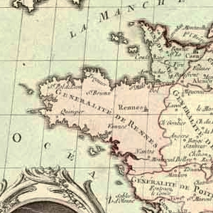
| Deskrifans | Partie bretonne de la carte intitulée "La France divisée en ses généralités ou intendances et pays d'Etats avec les chefs-lieux des élections, bailliages, territoires, prévôtés, subdélégations etc. Pour être insérée dans la lettre du roi pour la convocation des Etats généraux, du 24 janvier 1789." Gravure rehaussée de couleurs. Hors carte, à droite, liste des villes administratives des zones frontières du Nord et de l'Est, et à gauche, portrait anonyme du ministre Necker en médaillon, souligné de quatre vers de P.-L. Moline. "A Paris, chez Desnos, ingénieur géographe du roi, rue Saint-Jacques, au Globe" |
| Dedhyans | (UTC) |
| Pennfenten | |
| Awtour |
|
| This is a retouched picture, which means that it has been digitally altered from its original version. Modifications: Cropped to focus on Brittany, slightly enhanced colours.. The original can be viewed here: Carte de France 1789.jpg:
|
|
This work is in the public domain in its country of origin and other countries and areas where the copyright term is the author's life plus 70 years or fewer.
| |
| This file has been identified as being free of known restrictions under copyright law, including all related and neighboring rights. | |
Original upload log
This image is a derivative work of the following images:
- Image:Carte_de_France_1789.jpg licensed with PD-old
- 2005-06-27T22:21:38Z Yann 1789x1240 (281673 Bytes) Carte intitulée "La France divisée en ses généralités ou intendances et pays d'Etats avec les chefs-lieux des élections, bailliages, territoires, prévôtés, subdélégations etc. Pour être insérée dans la lettre du
Uploaded with derivativeFX
Istori an restren
Klyckyewgh war dhedhyans/eur rag gweles an folen dell o an termyn na.
| Dedhyans/Eur | Skeusennik | Mynsow | Devnydhyer | Kampol | |
|---|---|---|---|---|---|
| a-lemmyn | 17:09, 16 Gortheren 2008 | | 300 × 299 (88 KB) | QuartierLatin1968 | {{Information |Description=Partie bretonne de la carte intitulée "La France divisée en ses généralités ou intendances et pays d'Etats avec les chefs-lieux des élections, bailliages, territoires, prévôtés, subdélégations etc. Pour être inséré |
Devnydh an restren
Yma an folen a syw owth usya an restren ma:
Devnydh ollvysel an restren
Yma an wikis erel a syw ow tevnydhya an restren ma:
- Devnydh war br.wikipedia.org
- Devnydh war eu.wikipedia.org
- Devnydh war fi.wikipedia.org
- Devnydh war fr.wikipedia.org
- Devnydh war ja.wikipedia.org