
Restren:Volgarivermap.png
Nyns eus klerder ughella kavadow.
Volgarivermap.png (500 × 500 piksel, myns an restren: 155 KB, eghen MIME: image/png)
| Restren dhyworth Wikimedia Commons yw hebma. Yma diskwedhys a-woles derivadow dhyworth y folen deskrifans ena. | Mos dhe folen an restren war Wikimedia Commons |

|
This map image could be re-created using vector graphics as an SVG file. This has several advantages; see Commons:Media for cleanup for more information. If an SVG form of this image is available, please upload it and afterwards replace this template with
{{vector version available|new image name}}.
It is recommended to name the SVG file “Volgarivermap.svg”—then the template Vector version available (or Vva) does not need the new image name parameter. |
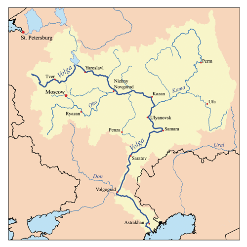
This is a map of the Volga River system. I, Karl Musser, created it based on USGS data.
I, the copyright holder of this work, hereby publish it under the following license:
This file is licensed under the Creative Commons Attribution-Share Alike 2.5 Generic license.
- Yma'n gwir dhywgh:
- a ranna – a dhasskrifa, lesranna ha treuskorra an ober
- a gemyska – a aswiwa an ober
- Yn-dann an ragselyow a syw:
- askrifans – Res yw dhywgh ri askrifans gwiw, provia kevren dhe'n lecyans, ha meneges mar peu chanjyow gwrys. Hwi a yll gul hemma yn fordh resonus a vynnowgh, mes ny yllir y wul yn fordh a broffo synser an lecyans dh'agas skoodhya po agas devnydh.
- ranna kehaval – Mar kwrewgh hwi chanjya, treusfurvya po drehevel war an ober ma, res yw dhywgh lesranna agas kevrohow yn-dann an keth lecyans hag an derowel, po lecyans kesplegadow.
derivative works
Derivative works of this file:
Istori an restren
Klyckyewgh war dhedhyans/eur rag gweles an folen dell o an termyn na.
| Dedhyans/Eur | Skeusennik | Mynsow | Devnydhyer | Kampol | |
|---|---|---|---|---|---|
| a-lemmyn | 17:06, 23 Gortheren 2007 | | 500 × 500 (155 KB) | Kmusser | Ural river fix |
| 14:50, 17 Hedra 2006 |  | 500 × 500 (40 KB) | Kmusser | ||
| 20:15, 31 Est 2006 |  | 500 × 500 (126 KB) | Kmusser | This is a map of the Volga River system. I, Karl Musser, created it based on USGS data. {{self|cc-by-sa-2.5}} Category:Maps of rivers |
Devnydh an restren
Yma an folen a syw owth usya an restren ma:
Devnydh ollvysel an restren
Yma an wikis erel a syw ow tevnydhya an restren ma:
- Devnydh war af.wikipedia.org
- Devnydh war als.wikipedia.org
- Devnydh war ang.wikipedia.org
- Devnydh war an.wikipedia.org
- Devnydh war ar.wikipedia.org
- Devnydh war arz.wikipedia.org
- Devnydh war ast.wikipedia.org
- Devnydh war as.wikipedia.org
- Devnydh war avk.wikipedia.org
- Tsna (kuksa ke Mokca)
- Volga (kuksa)
- Teza:VolgaBost
- Samara (kuksa)
- Borovka (kuksa)
- Tok (kuksa)
- Bolcoy Uran (kuksa)
- Mali Uran (kuksa)
- Bolcoy Kinel (kuksa)
- Buzuluk ke Volga (kuksa)
- Bolcoy Irgiz (kuksa)
- Kamelik (kuksa)
- Bolcaya Tcalikla (kuksa)
- Bolcoy Kucum (kuksa)
- Sura (kuksa)
- Alatir (kuksa)
- Baric (kuksa)
- Teza:SuraKuksa
- Teza:SamaraKuksa
- Teza:BolcoyIrgizKuksa
- Kadada (kuksa)
- Uza (kuksa)
- Ugra (kuksa ke Sura)
- Pyana (kuksa)
- Bezdna (kuksa)
- Inza (kuksa)
- Kirya (kuksa)
- Insar (kuksa)
- Oka (kuksa)
- Teza:OkaKuksa
- Mokca (kuksa)
Gweles devnydh ollvysel moy a'n restren ma.