
Restren:Maricopa County Incorporated and Planning areas Glendale highlighted.svg

Size of this PNG preview of this SVG file: 694 × 599 piksel. Klerderyow erel: 278 × 240 piksel | 556 × 480 piksel | 889 × 768 piksel | 1,185 × 1,024 piksel | 2,371 × 2,048 piksel | 940 × 812 piksel.
Restren wreydhek (Restren SVG, 940 × 812 piksel yn hanow, myns an restren: 1.05 MB)
| Restren dhyworth Wikimedia Commons yw hebma. Yma diskwedhys a-woles derivadow dhyworth y folen deskrifans ena. | Mos dhe folen an restren war Wikimedia Commons |
Berrskrif
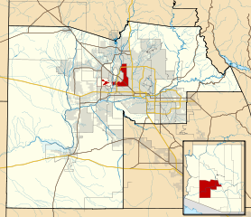
| Deskrifans | This map shows the incorporated areas and Indian reservation boundaries in Maricopa County, Arizona, along with water bodies and major highways and roads. Glendale is highlighted in red. Other incorporated cities are shown in gray, planning area borders for these cities and Indian reservation borders are shown as solid black lines. Changes from Previous Version: Updated the maps to include water bodies and to make "less boring" than the plain black/white/gray maps. Format was updated to match standards laid out by WikiProject Maps/Conventions. Map data is based on data from the following Webpage: Maricopa County Interactive GIS Map. I created this map in Inkscape. |
| Dedhyans | |
| Pennfenten | My own work, based on government information |
| Awtour | Ixnayonthetimmay |
| Kummyas (Dastevnydhya an restren ma) |
Public Domain |
| Other versions | See Category:Maps of Maricopa County for other versions of this image. |
Leshyans
| I, the copyright holder of this work, release this work into the public domain. This applies worldwide. In some countries this may not be legally possible; if so: I grant anyone the right to use this work for any purpose, without any conditions, unless such conditions are required by law. |
Istori an restren
Klyckyewgh war dhedhyans/eur rag gweles an folen dell o an termyn na.
| Dedhyans/Eur | Skeusennik | Mynsow | Devnydhyer | Kampol | |
|---|---|---|---|---|---|
| a-lemmyn | 06:32, 20 Me 2011 | | 940 × 812 (1.05 MB) | Ixnayonthetimmay | Uploading new version |
| 04:10, 30 Est 2008 |  | 900 × 800 (423 KB) | Ixnayonthetimmay | == Summary == {{Information |Description=This map shows the incorporated areas and unincorporated areas in Maricopa County, Arizona. [[:en:Glendale, Arizona| | |
| 00:16, 16 Gwynngala 2007 |  | 900 × 800 (384 KB) | Ixnayonthetimmay | {{Information |Description= |Source= |Date= |Author= |Permission= |other_versions= }} | |
| 10:00, 28 Me 2007 |  | 900 × 780 (329 KB) | Ixnayonthetimmay | ||
| 00:07, 22 Me 2007 |  | 900 × 780 (318 KB) | Ixnayonthetimmay | ||
| 05:05, 30 Genver 2007 |  | 904 × 758 (189 KB) | Ixnayonthetimmay | {{Information |Description=This map shows the incorporated areas in Maricopa County, Arizona, highlighting Glendale in red. It also shows the boundaries for the |
Devnydh an restren
Yma an folen a syw owth usya an restren ma:
Devnydh ollvysel an restren
Yma an wikis erel a syw ow tevnydhya an restren ma:
- Devnydh war ar.wikipedia.org
- Devnydh war arz.wikipedia.org
- Devnydh war br.wikipedia.org
- Devnydh war ca.wikipedia.org
- Devnydh war ceb.wikipedia.org
- Devnydh war de.wikipedia.org
- Devnydh war el.wikipedia.org
- Devnydh war eo.wikipedia.org
- Devnydh war es.wikipedia.org
- Devnydh war eu.wikipedia.org
- Devnydh war fa.wikipedia.org
- Devnydh war fi.wikipedia.org
- Devnydh war fr.wikipedia.org
- Devnydh war ga.wikipedia.org
- Devnydh war gl.wikipedia.org
- Devnydh war hr.wikipedia.org
- Devnydh war ht.wikipedia.org
- Devnydh war hu.wikipedia.org
- Devnydh war id.wikipedia.org
- Devnydh war ja.wikipedia.org
- Devnydh war mrj.wikipedia.org
- Devnydh war ms.wikipedia.org
- Devnydh war pt.wikipedia.org
- Devnydh war ro.wikipedia.org
- Devnydh war sco.wikipedia.org
- Devnydh war sr.wikipedia.org
- Devnydh war sw.wikipedia.org
- Devnydh war ta.wikipedia.org
- Devnydh war tr.wikipedia.org
- Devnydh war tt.wikipedia.org
- Devnydh war ur.wikipedia.org
- Devnydh war vi.wikipedia.org
- Devnydh war vo.wikipedia.org
- Devnydh war www.wikidata.org