
Restren:Map missoula floods.gif
Nyns eus klerder ughella kavadow.
Map_missoula_floods.gif (668 × 481 piksel, myns an restren: 24 KB, eghen MIME: image/gif)
| Restren dhyworth Wikimedia Commons yw hebma. Yma diskwedhys a-woles derivadow dhyworth y folen deskrifans ena. | Mos dhe folen an restren war Wikimedia Commons |
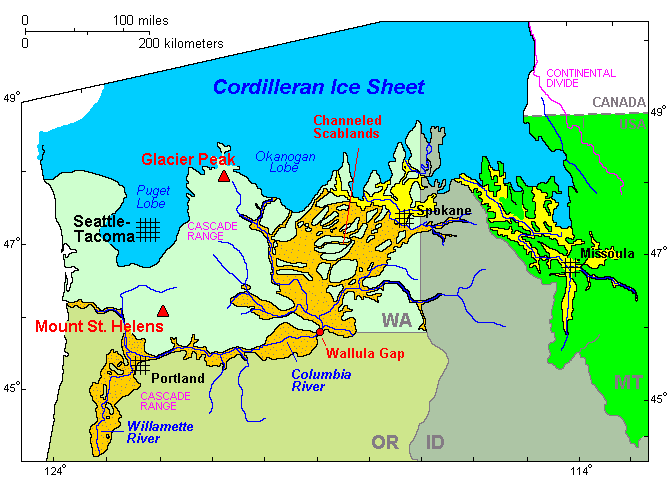
Legend
Cordilleran Ice Sheet
maximum extent of Glacial Lake Missoula (eastern) and Glacial Lake Columbia (western)
areas swept by Missoula and Columbia floods
Berrskrif
| Deskrifans | Map of the Missoula Floods |
| Pennfenten | http://vulcan.wr.usgs.gov/Volcanoes/ColumbiaPlateau/summary_columbia_plateau.html |
| Awtour | USGS |
| Kummyas (Dastevnydhya an restren ma) |
public domain |

|
This map image could be re-created using vector graphics as an SVG file. This has several advantages; see Commons:Media for cleanup for more information. If an SVG form of this image is available, please upload it and afterwards replace this template with
{{vector version available|new image name}}.
It is recommended to name the SVG file “Map missoula floods.svg”—then the template Vector version available (or Vva) does not need the new image name parameter. |
Leshyans
This image is in the public domain in the United States because it only contains materials that originally came from the United States Geological Survey, an agency of the United States Department of the Interior. For more information, see the official USGS copyright policy.
|
Istori an restren
Klyckyewgh war dhedhyans/eur rag gweles an folen dell o an termyn na.
| Dedhyans/Eur | Skeusennik | Mynsow | Devnydhyer | Kampol | |
|---|---|---|---|---|---|
| a-lemmyn | 00:40, 6 Gwynngala 2009 | | 668 × 481 (24 KB) | Peteforsyth | moved scale of miles/km; cropped out now-redundant legend. |
| 00:26, 6 Gwynngala 2009 |  | 668 × 594 (26 KB) | Peteforsyth | trimmed it | |
| 02:12, 18 Est 2009 |  | 680 × 700 (30 KB) | Peteforsyth | {{Information |Description=Map of the Missoula Floods |Source=http://vulcan.wr.usgs.gov/Volcanoes/ColumbiaPlateau/summary_columbia_plateau.html |Date= |Author=USGS |Permission=public domain |other_versions= }} |
Devnydh an restren
Yma an folen a syw owth usya an restren ma:
Devnydh ollvysel an restren
Yma an wikis erel a syw ow tevnydhya an restren ma:
- Devnydh war ca.wikipedia.org
- Devnydh war de.wikipedia.org
- Devnydh war en.wikipedia.org
- Devnydh war es.wikipedia.org
- Devnydh war fr.wikipedia.org
- Devnydh war he.wikipedia.org
- Devnydh war hy.wikipedia.org
- Devnydh war it.wikipedia.org
- Devnydh war pl.wikipedia.org
- Devnydh war ru.wikipedia.org
- Devnydh war uk.wikipedia.org