
Restren:Baldhu Church - geograph.org.uk - 377718.jpg
Nyns eus klerder ughella kavadow.
Baldhu_Church_-_geograph.org.uk_-_377718.jpg (640 × 480 piksel, myns an restren: 98 KB, eghen MIME: image/jpeg)
| Restren dhyworth Wikimedia Commons yw hebma. Yma diskwedhys a-woles derivadow dhyworth y folen deskrifans ena. | Mos dhe folen an restren war Wikimedia Commons |
Berrskrif
| Deskrifans |
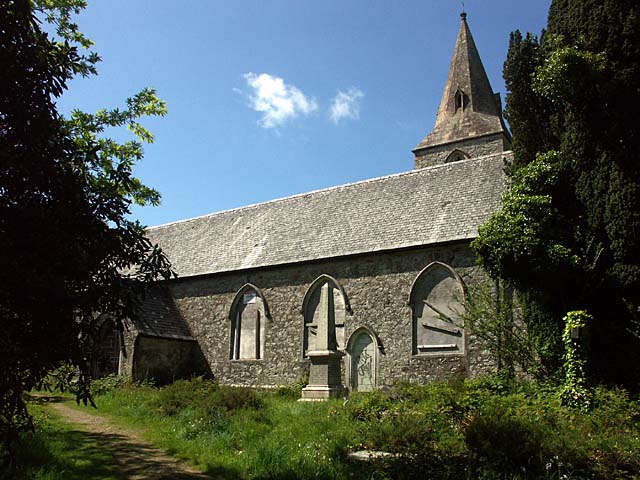
English: Baldhu Church. The ecclesiastical parish of Baldhu was formed in 1847 from parts of Kea and Kenwyn parishes. The church is now closed but the church yard is still used for burials. Baldhu is Cornish for Black Mine.
Now converted into two dwellings. See 1265961 |
| Dedhyans | |
| Pennfenten | From geograph.org.uk |
| Awtour | Fred James |
| Askrifans (required by the license) | Fred James / Baldhu Church / |
| Camera location | | View this and other nearby images on: OpenStreetMap |
|---|
_heading:337.00&language=kw)
| Object location | | View this and other nearby images on: OpenStreetMap |
|---|
_heading:337.00&language=kw)
Leshyans

|
This image was taken from the Geograph project collection. See this photograph's page on the Geograph website for the photographer's contact details. The copyright on this image is owned by Fred James and is licensed for reuse under the Creative Commons Attribution-ShareAlike 2.0 license.
|
This file is licensed under the Creative Commons Attribution-Share Alike 2.0 Generic license.
Askrifans: Fred James
- Yma'n gwir dhywgh:
- a ranna – a dhasskrifa, lesranna ha treuskorra an ober
- a gemyska – a aswiwa an ober
- Yn-dann an ragselyow a syw:
- askrifans – Res yw dhywgh ri askrifans gwiw, provia kevren dhe'n lecyans, ha meneges mar peu chanjyow gwrys. Hwi a yll gul hemma yn fordh resonus a vynnowgh, mes ny yllir y wul yn fordh a broffo synser an lecyans dh'agas skoodhya po agas devnydh.
- ranna kehaval – Mar kwrewgh hwi chanjya, treusfurvya po drehevel war an ober ma, res yw dhywgh lesranna agas kevrohow yn-dann an keth lecyans hag an derowel, po lecyans kesplegadow.
Istori an restren
Klyckyewgh war dhedhyans/eur rag gweles an folen dell o an termyn na.
| Dedhyans/Eur | Skeusennik | Mynsow | Devnydhyer | Kampol | |
|---|---|---|---|---|---|
| a-lemmyn | 20:10, 4 Genver 2011 | | 640 × 480 (98 KB) | GeographBot | == {{int:filedesc}} == {{Information |description={{en|1=Baldhu Church The ecclesiastical parish of Baldhu was formed in 1847 from parts of Kea and Kenwyn parishes. The church is now closed but the church yard is still used for burials. Baldhu is Cornish |
Devnydh an restren
Yma an folen a syw owth usya an restren ma:
Devnydh ollvysel an restren
Yma an wikis erel a syw ow tevnydhya an restren ma:
- Devnydh war dag.wikipedia.org
- Devnydh war en.wikipedia.org
- Devnydh war eu.wikipedia.org
- Devnydh war www.wikidata.org