
Restren:Arches National Park Map.jpg
Myns an ragwel ma: 400 × 600 piksel. Klerderyow erel: 160 × 240 piksel | 320 × 480 piksel | 512 × 768 piksel | 682 × 1,024 piksel | 2,500 × 3,750 piksel.
Restren wreydhek (2,500 × 3,750 piksel, myns an restren: 3.52 MB, eghen MIME: image/jpeg)
| Restren dhyworth Wikimedia Commons yw hebma. Yma diskwedhys a-woles derivadow dhyworth y folen deskrifans ena. | Mos dhe folen an restren war Wikimedia Commons |
|
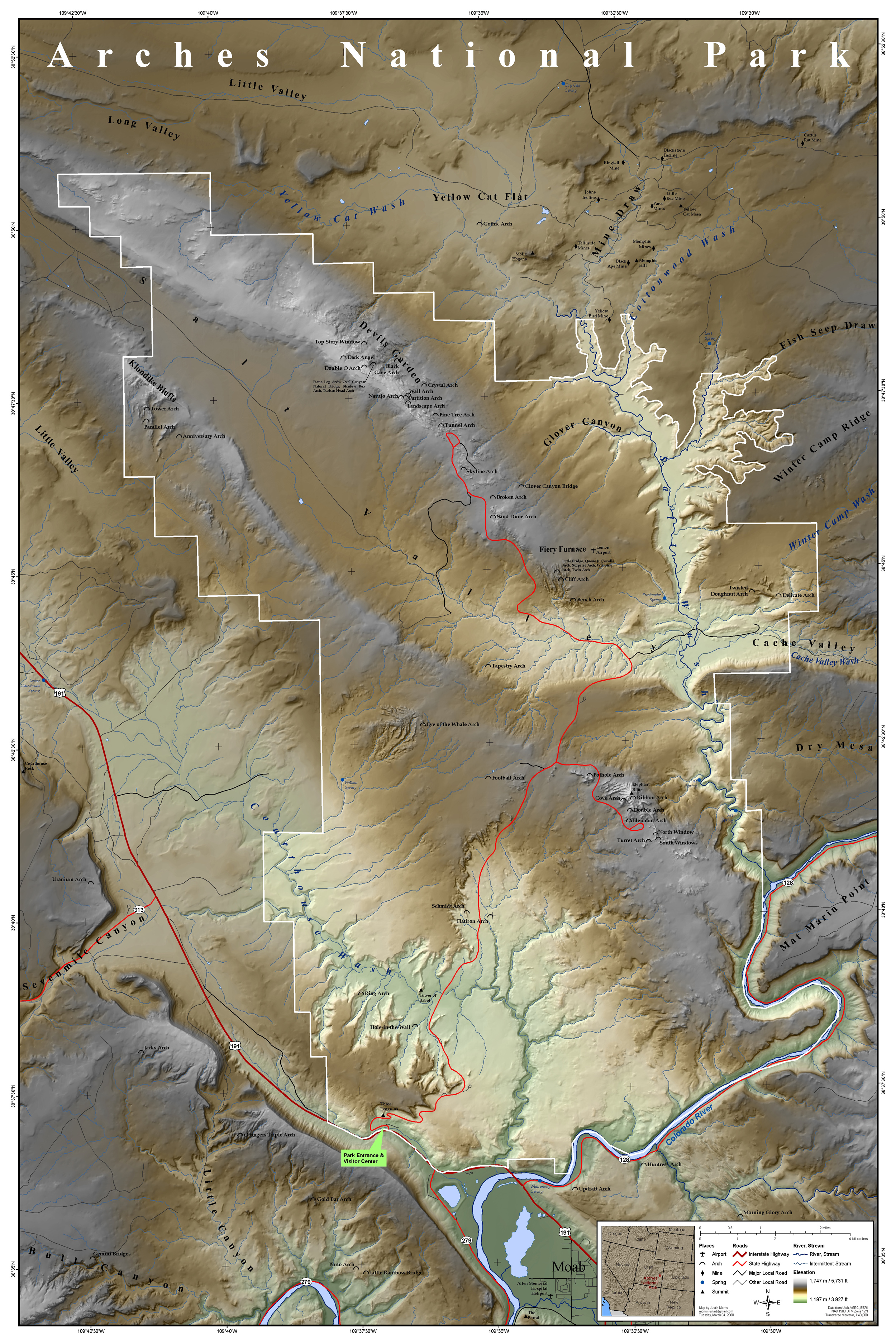
| Deskrifans | Map of Arches National Park, Utah, United States showing predominant features such as arches, peaks, rivers and streams, mines, and roads. | ||
| Dedhyans | |||
| Pennfenten | This map was entirely self made using ArcGIS. Map data is from Utah AGRC, ESRI and the USGS. | ||
| Awtour | Justinmorris (talk) | ||
| Kummyas (Dastevnydhya an restren ma) |
I, the copyright holder of this work, hereby publish it under the following license: Yma an restren ma yn-dann an leshyans Creative Commons Attribution-Share Alike 3.0 Unported.
|
Istori an restren
Klyckyewgh war dhedhyans/eur rag gweles an folen dell o an termyn na.
| Dedhyans/Eur | Skeusennik | Mynsow | Devnydhyer | Kampol | |
|---|---|---|---|---|---|
| a-lemmyn | 17:15, 16 Meurth 2008 | | 2,500 × 3,750 (3.52 MB) | Justinmorris | {{FeaturedPicture|Arches National Park Map}} == Summary == {{Information |Description=Map of Arches National Park, Utah, United States showing predominant features such as arches, peaks, rivers and streams, mines, and roads. |S |
Devnydh an restren
Yma an 2 folen a syw owth usya an restren ma:
Devnydh ollvysel an restren
Yma an wikis erel a syw ow tevnydhya an restren ma:
- Devnydh war en.wikipedia.org
- Portal:Utah
- Portal:North America/Selected picture
- Portal:Utah/Featured content
- Portal:Maps/Selected picture
- User talk:Justinmorris/Archive01
- Wikipedia:Picture peer review/Archives/Jan-Mar 2008
- Wikipedia:Featured pictures thumbs/11
- Wikipedia:Featured picture candidates/March-2008
- Wikipedia:Picture peer review/Arches National Park Map
- User:Justinmorris
- Wikipedia:Featured picture candidates/Arches National Park Map
- Wikipedia:Wikipedia Signpost/2008-03-17/Features and admins
- User:Justinmorris/Maps
- Wikipedia:Featured pictures/Diagrams, drawings, and maps/Maps
- User talk:Justinmorris
- Arches National Park
- Wikipedia:Wikipedia Signpost/2008-03-17/SPV
- Wikipedia:Picture of the day/October 2008
- Template:POTD/2008-10-08
- Portal:Maps/Selected picture/39
- Portal:North America/Selected picture/32
- Wikipedia:WikiProject United States/Recognized content
- Wikipedia:WikiProject United States/Quality content
- Wikipedia:WikiProject United States/Featured pictures
- Wikipedia:Wikipedia Signpost/Single/2008-03-17
- Devnydh war fr.wikipedia.org
- Devnydh war he.wikipedia.org
- Devnydh war is.wikipedia.org
- Devnydh war ml.wikipedia.org
- Devnydh war tr.wikipedia.org
- Devnydh war zh.wikipedia.org