
Restren:Quay Street, Ammanford (Recreated) - geograph.org.uk - 299161.jpg
Nyns eus klerder ughella kavadow.
Quay_Street,_Ammanford_(Recreated)_-_geograph.org.uk_-_299161.jpg (640 × 451 piksel, myns an restren: 86 KB, eghen MIME: image/jpeg)
| Restren dhyworth Wikimedia Commons yw hebma. Yma diskwedhys a-woles derivadow dhyworth y folen deskrifans ena. | Mos dhe folen an restren war Wikimedia Commons |
_-_geograph.org.uk_-_299161.jpg?uselang=kw)
Berrskrif
| Deskrifans |
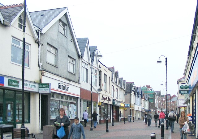
English: Quay Street, Ammanford (Recreated) Another shot of Quay Street recreated from the Frith collection.
This time it is a 1936 shot ( http://www.francisfrith.com/search/wales/dyfed/ammanford/photos/ammanford_87811.htm ) of the west side of the street running from south of where Hall Street joins it, up to the town square. The roof line is much the same in both shots, but the modern buildings have lost all their bay windows and awnings. |
| Dedhyans | |
| Pennfenten | From geograph.org.uk |
| Awtour | Nigel Davies |
| Askrifans (required by the license) | Nigel Davies / Quay Street, Ammanford (Recreated) / |
| Object location | | View this and other nearby images on: OpenStreetMap |
|---|
_-_geograph.org.uk_-_299161.jpg¶ms=051.791770_N_-003.987500_E_globe:Earth_class:object_type:object_source:geograph-osgb36(SN63021221)_heading:315.00&language=kw)
Leshyans

|
This image was taken from the Geograph project collection. See this photograph's page on the Geograph website for the photographer's contact details. The copyright on this image is owned by Nigel Davies and is licensed for reuse under the Creative Commons Attribution-ShareAlike 2.0 license.
|
This file is licensed under the Creative Commons Attribution-Share Alike 2.0 Generic license.
Askrifans: Nigel Davies
- Yma'n gwir dhywgh:
- a ranna – a dhasskrifa, lesranna ha treuskorra an ober
- a gemyska – a aswiwa an ober
- Yn-dann an ragselyow a syw:
- askrifans – Res yw dhywgh ri askrifans gwiw, provia kevren dhe'n lecyans, ha meneges mar peu chanjyow gwrys. Hwi a yll gul hemma yn fordh resonus a vynnowgh, mes ny yllir y wul yn fordh a broffo synser an lecyans dh'agas skoodhya po agas devnydh.
- ranna kehaval – Mar kwrewgh hwi chanjya, treusfurvya po drehevel war an ober ma, res yw dhywgh lesranna agas kevrohow yn-dann an keth lecyans hag an derowel, po lecyans kesplegadow.
Istori an restren
Klyckyewgh war dhedhyans/eur rag gweles an folen dell o an termyn na.
| Dedhyans/Eur | Skeusennik | Mynsow | Devnydhyer | Kampol | |
|---|---|---|---|---|---|
| a-lemmyn | 21:44, 14 Kevardhu 2010 | | 640 × 451 (86 KB) | GeographBot | == {{int:filedesc}} == {{Information |description={{en|1=Quay Street, Ammanford (Recreated) Another shot of Quay Street recreated from the Frith collection. This time it is a 1936 shot ( http://www.francisfrith.com/search/wales/dyfed/ammanford/photos/amm |
Devnydh an restren
Yma an folen a syw owth usya an restren ma:
Devnydh ollvysel an restren
Yma an wikis erel a syw ow tevnydhya an restren ma:
- Devnydh war cs.wikipedia.org
- Devnydh war en.wikipedia.org
- Devnydh war eu.wikipedia.org
- Devnydh war fa.wikipedia.org
- Devnydh war fi.wikipedia.org
- Devnydh war gd.wikipedia.org
- Devnydh war nl.wikipedia.org
- Devnydh war ru.wikipedia.org
- Devnydh war simple.wikipedia.org
_-_geograph.org.uk_-_299161.jpg)