
Restren:Map of Wyoming County Pennsylvania With Municipal and Township Labels.png
Nyns eus klerder ughella kavadow.
Map_of_Wyoming_County_Pennsylvania_With_Municipal_and_Township_Labels.png (429 × 314 piksel, myns an restren: 30 KB, eghen MIME: image/png)
| Restren dhyworth Wikimedia Commons yw hebma. Yma diskwedhys a-woles derivadow dhyworth y folen deskrifans ena. | Mos dhe folen an restren war Wikimedia Commons |
Berrskrif
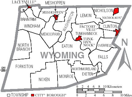
Map of Wyoming County, Pennsylvania, United States with township and municipal boundaries is taken from US Census website [1] and modified by User:Ruhrfisch in April 2006. My modifications licensed under the GNU Free Documentation License.
Source: US Census website [2]
Leshyans

|
Permission is granted to copy, distribute and/or modify this document under the terms of the GNU Free Documentation License, Version 1.2 or any later version published by the Free Software Foundation; with no Invariant Sections, no Front-Cover Texts, and no Back-Cover Texts. A copy of the license is included in the section entitled GNU Free Documentation License. |
| Yma an restren ma yn-dann an leshyans Creative Commons Attribution-Share Alike 3.0 Unported. | ||
| ||
| This licensing tag was added to this file as part of the GFDL licensing update. |
Istori an restren
Klyckyewgh war dhedhyans/eur rag gweles an folen dell o an termyn na.
| Dedhyans/Eur | Skeusennik | Mynsow | Devnydhyer | Kampol | |
|---|---|---|---|---|---|
| a-lemmyn | 14:31, 4 Ebrel 2006 | | 429 × 314 (30 KB) | Ruhrfisch | Map of Wyoming County, Pennsylvania, United States with township and municipal boundaries is taken from US Census website [http://www2.census.gov/geo/maps/general_ref/cousub_outline/cen2k_pgsz/pa_cosub.pdf] and modified by User:Ruhrfisch in April 2006 |
Devnydh an restren
Yma an folen a syw owth usya an restren ma:
Devnydh ollvysel an restren
Yma an wikis erel a syw ow tevnydhya an restren ma:
- Devnydh war ceb.wikipedia.org
- Devnydh war de.wikipedia.org
- Devnydh war en.wikipedia.org
- Devnydh war es.wikipedia.org
- Devnydh war ja.wikipedia.org
- Devnydh war pl.wikipedia.org
- Devnydh war pt.wikipedia.org
- Devnydh war www.wikidata.org